


2021 02 21

Ardeiserois
User
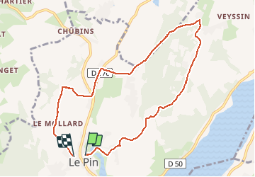

Length
9.4 km

Max alt
686 m

Uphill gradient
280 m
Km-Effort
13.1 km

Min alt
514 m

Downhill gradient
272 m
Boucle
Yes
Creation date :
2021-02-21 11:58:20.986
Updated on :
2021-02-21 16:17:22.923
2h27
Difficulty : Very easy

FREE GPS app for hiking
 SityTrail
IGN / Geographical institutes
SityTrail Plus
The world is yours!
About
Trail Walking of 9.4 km to be discovered at Auvergne-Rhône-Alpes, Isère, Villages du Lac de Paladru. This trail is proposed by Ardeiserois.
Positioning
Country:
France
Region :
Auvergne-Rhône-Alpes
Department/Province :
Isère
Municipality :
Villages du Lac de Paladru
Location:
Unknown
Start:(Dec)
Start:(UTM)
695973 ; 5036755 (31T) N.
Comments